
Water Management
WM-Form Land Forming Solution
|
WM-Form allows you to design variable-shaped fields and topography based on the best use of existing contours, the water needs of individual crops, and even individual farming practices.
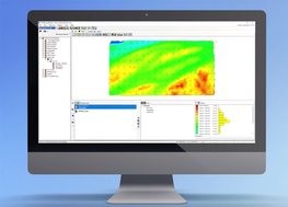
As a complete end-to-end workflow, WM-Form allows you to perform field survey, analyze topography, create an optimized design, export earthworks reports and control files, and conduct land forming operations on the machine. The WM-Form software can also be used to generate earthworks volume estimates and produce detailed project bids for contractors. |
- Level fields with single or multiple planes using a best-fit or custom plane, or with multiple hinges
- Drain water in any direction or to a linear feature such as a ditch or existing drainage system
- Create multi-direction variable slope designs to optimize the surface for furrow irrigation
- Create section lines and design each section individually
- Generate multiple design variations for the field, then compare them in 3D view against the original topography
- Produce 2D cut/fill estimates and reports
WM-Drain Farm Drainage Solution
|
The Trimble® WM-Drain® farm drainage solution is a concept-to-completion toolset that streamlines the survey, analysis, design, installation, and mapping steps of surface and subsurface drainage.
The WM-Drain solution ensures optimal 3D drain placement, which improves crop yields by controlling ponding, optimizing root depth, maximizing planting seasons, and minimizing nutrient loss. |
- Seamless, integrated solution for survey, analysis, design, installation, and mapping steps of surface and subsurface drainage projects
- Software for analysis and optimal 3D drainage design
- On-the-go design capabilities
- T3™ Enhanced Terrain Compensation Technology for roll-corrected 3D positioning
- Wireless data transfer between the farm office, vehicles, and workers in the field
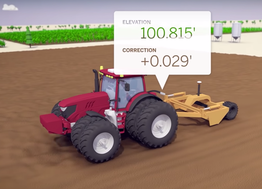
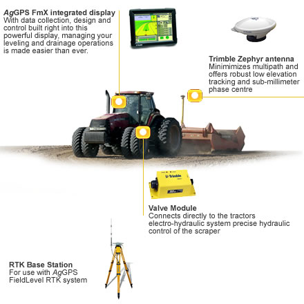
FieldLevel II System
|
3-D leveling system for water management
The Trimble® AgGPS® FieldLevel II system for water management can help keep water costs down and efficiently distribute water by maintaining grade. Topographic Data can be collected via the AgGPS FmX™ integrated display while using the AgGPS Autopilot™ automated steering system, or connected to an RTK receiver stand-alone. Using the AgGPS 442 GNSS or AgGPS 432 receivers you can collect detailed topography data, allowing you to precisely match scrapers to the survey data when it is time to level. With the FmX integrated display you can run AgGPS Autopilot for accurate passes at the same time as FieldLevel II further maximizing the efficiency of your equipment. With a topographic survey you can calculate a best-fit levelling and section the field using the AutoPlane functionality right on the display, or use the AgGPS MultiPlane software to design more complex scenarios in your office and import the design back into the FieldLevel II system. When levelling the field, AgGPS FieldLevel II system will automatically raise and lower the blade on the scrapers based on the tractors location. Dirt will be moved to obtain the MultiPlane or AutoPlane design. |
For information and purchasing call:
+1 (712) 251-8954